Many old bridges still span the Longjiang River in western Yunnan.
In 1639, the renowned Ming dynasty explorer Xu Xiake 徐霞客 was travelling westwards through Yunnan in direction of Tengchong 腾冲, then a small trading post in the highlands east of Burma. He had already crossed the mighty Mekong (or Lancang River 澜沧江) and the Nujiang 怒江 and had ascended the towering Gaoligong Mountains 高黎贡山, a mountain range with few good crossings: sweltering in summer and icy in winter, the middle of May when he embarked on his journey was probably the best time.
Descending from the mountain ridge he walked down several Chinese miles to encounter a few small villages. He noted in his diary:
自过分水闗,雨阵时至,至竹笆铺始晴,数家夹道成衢,有卖鹿肉者,予买而炙脯。Since passing Fenshui Guan, intermittent rain showers occurred until reaching Zhuba Pu, where it began to clear up. Along the road lined with a few houses forming a market, there were vendors selling deer meat; I bought some and grilled it.
The region was certainly set up for travellers like him. He continued:
于是直下三里,为茶菴,又西下五里及山麓坡间,始盘塍为田,其下即龙川江,自北而南,水不及潞江三分之一而奔坠甚沸。西崖削壁,横江东则平坡,环塍行塍间半里,抵龙川江东岸。Then, going straight down for three li, I reached Chaan. Continuing westward for another five li through the slopes at the foot of the mountains, the land began to transform into terraced fields. Below this is Longchuan River, flowing from north to south. The river's volume is less than one-third that of Lu Jiang, yet it rushes and plunges very turbulently. On the west, cliffs are carved out, forming a wall along the river. To the east, there's a level slope surrounded by circular ditches. Walking along these ditches for half a li, I reached the eastern bank of Longchuan River.
Even if not even half as wide as the Nujiang, the river nevertheless posed a formidable barrier. But just a bit further north he found a bridge:
溯江北行又半里,有铁锁桥架江上,其制两头悬练,中穿板如织法,一如兰沧之铁锁桥,而狭,止得其半。由桥西即蹑级南上半里,为龙闗,数十家当坡而居,有税司以𣙜负贩者。Going northward along the river for another half li, there is an iron chain bridge spanning the river. The construction of this bridge involves suspending chains at both ends, with planks threaded through them in a manner similar to weaving, just like the iron chain bridge across the Lancang, but narrower, covering only half the distance. From the west side of the bridge, climbing the steps to the south for half a li, I arrived at Longguan, where dozens of houses are located along the slope, and there is a tax office that taxes the bearers and traders.
This bridge, now just called Longjiang Bridge 龙江桥, was first built as a rattan bridge during the Yuan dynasty, then during the Ming strengthened into an iron chain bridge. Such as bridge is still extant there today.
On his return journey, he once again passed this bridge, noting on June 21, 1639:
二十一日,平明起,饭自橄榄坡东下五里,抵龙川江西岸。过巡检司,即下度桥。西岸峻若堵墙,乃循岸北向,叠级始达桥。桥东有阁,登之可眺江流夭矫之势。On the 21st day, I got up at dawn and after having breakfast, I descended five li eastward from the Olive Slope to the western bank of the Longchuan River. After passing the patrol inspector's office, I immediately went down to cross the bridge. The western bank was steep like a wall, so I followed the bank northward, ascending in steps until I reached the bridge. To the east of the bridge, there was a pavilion. Climbing up to it, I could overlook the river's flow, winding and meandering beautifully.
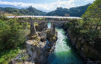
But this bridge is not the only ancient bridge still extant spanning the river. Dozens of kilometers further upstream, in a remote location remains Minfu Bridge 民福桥, a cantilevered wooden roofed construction. That bridge seems far from any trade route.
Further north, the upper part of the Longjiang flows through a broader valley, where just south of Qushi 曲石 remain the bridgeheads of a old chain bridge, Shangyang bridge, 向阳桥, which once served the traffic from the upper valley to Tengchong 腾冲. Xu Xiake, coming from the north travelled through here a few weeks later, noted in his diary for the May 31st, 1639:
乃下半里,稍西转,迎流行峡中。有数家倚峡北,是为曲石。而峡之西,其内反辟而成坞,亦有村庐倚之,则峡水之所从来也。于是南截峡流,又上坡行。坡间二里,有村当路左,亦曲石之村庐也。又南三里,乃随坡西转,始见坡南坞大开。西行一里,又南向峻下者一里,及坞底,有桥跨江,亦铁锁交络而覆亭于上者,是为曲石桥。Having descended half a li, I slightly turned westward, following the stream through the gorge. There were several houses leaning against the north of the gorge, known as Qushi. To the west of the gorge, inside it, a cove was naturally formed, and there were also village houses nestled against it, from where the waters of the gorge originated. Then, heading south, cutting across the flow of the gorge, I continued uphill. Within a distance of two li along the slope, there was a village on the left side of the road, also part of the Qu Shi community. Further south for three li, following the slope as it turned westward, I began to see a large opening in the cove on the southern side of the slope. After traveling westward for one li and then turning south, descending steeply for another li, I reached the bottom of the cove. There, a bridge spanned the river, also adorned with interlocking iron chains and covered with a pavilion on top. This was known as the Qushi Bridge.
Along the river are a number of further old cantilevered wooden bridges: the Yezhuqing bridge 野猪箐桥, the Shiqiang bridge 石墙木悬臂桥, the High Bridge 高桥, which spans a deep ravine, and Tongji Brigde 通济桥. Between them is Yongan Bridge 永安桥, a cable bridge already built for vehicle transport.
Most of these bridges have seen substantial repairs in the last few years, somewhat changing their character. But others, like Longluo bridge 龙落桥, have entirely been replaced by modern constructions.
Slideshow
Click to see more